Hi folks, this is guest blogger Mike. I’m a riding buddy of Rob’s and he asked me to share an experience my wife and I had last week riding the GAP. For those of you who live in Milford, PA, when someone refers to the “GAP” you know they are talking about the Delaware Water Gap. To those in southwestern PA, the GAP is the Great Allegheny Passage, a nearly 150 mile rail to trail biking and hiking route that retraces the former B+O Railroad line through the Allegheny Mountains from Cumberland, MD to Pittsburgh, PA.

The start in Cumberland, MD
The GAP today uses the series of tunnels, bridges and viaducts that were built in the early 1900’s to connect the Chesapeake Bay to the Ohio River. A separate trail, the 185 mile long C+O Canal Trail, connects Washington D.C. to Cumberland, MD. The GAP trail fully opened in 2013 after years of work rebuilding the tunnels and bridges, and then paving the entire trail with crushed limestone. The last 15 miles of the trail into Pittsburgh are paved with asphalt. Logistically, the GAP is very easy to access and travel on. Each town that the trail passes through has parking and toilets for day riders. Some towns have water fountains available and
a few even have a small bike repair stand fully equipped with tools and tire pumps. Each mile of the trail is marked with a concrete post so you always know how far along you are. There are also dozens of campgrounds along the way for those who chose to camp vs. staying in hotels or Bed and Breakfast Inn’s. Many of the campgrounds are free for bikers and are even stocked with free firewood. The larger towns on the GAP have B+B’s that specifically cater to cyclist. There are also many outfitters that will plan your entire trip, complete with a guided support vehicle so all you need to do is pedal to the next destination. Amtrak also operates the “Capital” Line which has a train car with a bike storage room that stops in Pittsburgh, Connellsville, PA, and Cumberland to transport you and your bike before or after the ride.

My wife and I decided to try this ride the first week of October to take advantage of the fall foliage and the cooler riding temperatures. We started in Cumberland, which was about a 300 mile drive from Milford. There are a few hotels in Cumberland near the trailhead and they all cater to the cyclists. We were allowed to bring our bikes into our room. There is also free parking near the trailhead, under the interstate overpass, and it was a safe place to leave your car for a week. There is also a local bike shop only a few yards from the start just in case of any last minute adjustments or needed supplies. The National Park Service has an information
center at the trailhead with maps of the trail and brochures of each town along the way to Pittsburgh.
I planned our trip to ride a total of 4 days, with a day off in the middle. My wife is a novice rider and had never ridden further than 30 miles in one day. She had no problems conquering the GAP. The trail is nearly flat with the exception of the first 23 miles from Cumberland to the Eastern Continental Divide. The total climb to the Divide was 1800 feet with a nearly constant grade of only 1.6%. My wife handled the climb without any difficulty. The scenery was breathtaking and we stopped several times for photo ops. We stayed the first night in Myersdale, PA (32 miles). Our B+B was one block from the trail and had secure bike storage in the basement. We met several other riders during our stay and had fun exchanging stories.
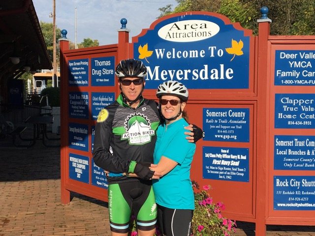
Myersdale, PA The second day was an equally scenic ride to Ohiopyle, PA (40 miles). We spent an extra day here to visit Frank Lloyd Wright’s “Fallingwater” and also to do some hiking around the Youghiogheny River. Ohiopyle is also a great place to do some white water rafting on a day off. The 3rd day of riding followed the “Yough” to West Newton, PA (42 miles). The rain was off and on this day which made for a muddy ride, but the scenery was still amazing. My wife’s bike had
a minor mechanical issue we were able to get fixed in Connersville at a bike shop right on the trail.
The final day to Pittsburgh (35 miles) saw the trail change from a scenic ride in the woods to an urban feel the final 15 miles. Multiple bridges over the Monongahela River made for several more photo ops with the city of Pittsburgh in the background. Our son, who is a student at the University of Pittsburgh, joined us on his bike for the final 7 miles to Point State Park, where the GAP ends. This is where the Monongahela and Allegheny Rivers join to form the Ohio River. After an evening in Pittsburgh, we rode the Amtrak “Capital” back to Cumberland to retrieve our car.
Overall we had an amazing experience on this ride and would definitely do it again. It is something that even a novice rider could do easily. Meeting other cyclists along the way was one of the highlights of the trip. As for the song that would best describe this journey…. it would have to be “She’ll be coming around the mountain when she comes”!!! For more info on the GAP visit: http://www.GAPtrail.org

Some more pics of this awesome ride!


