Navigating the High Country

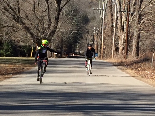
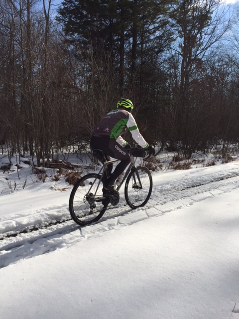
Another warm February day! 50 degrees and sunny! You couldn’t ask for more! While checking out this weekends weather, and since the roads are still covered in way too much salt, I decided to venture out and try a ride pretty far off the beaten path: the climb up the High Knob to the fire tower.

bo 5

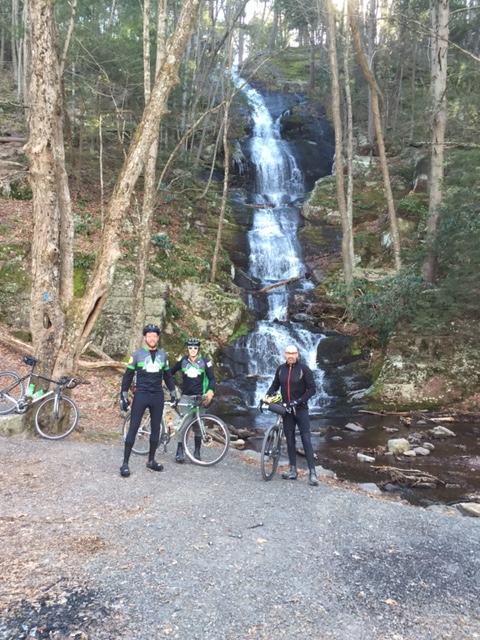
I met up with Will at the Maple Run parking area on Rt. 402 in Blooming Grove Township. We turned right out of the parking area onto Rt. 402, and after a mile, we hung a left, hit the gravel, and immediately started to climb. The High Knob Road is a loose gravel surface, making it almost impossible to get out of the saddle on the way up. The road winds its way skyward for about 1.75 miles, and just as you think you’re at the top, the grade steepens sharply. Another quarter mile, and finally I can breathe.

bo

bo 3
Fire Tower and Cell Towers atop the High Knob

At 2100 feet, the High Knob is the highest elevation in Pike County. The view is pretty darn good too! Now, time to descend through the loose stuff. The ride down was fantastic! A nice reward for a tough climb. At the bottom, we beared right onto Hobday Road, a more packed down gravel surface made for a smoother ride. After a few miles, Hobday turned into High Line Road. High Line is a road that seems to literally pull you as you swoop up and down, and twist and turn through the Pennsylvania State Forest.

bo 4

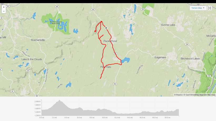
As we came to a 3 way intersection of gravel roads, we were met with a funky sign post, pointing you in the direction towards any one of the many hunting cabins that litter the State Forest. Intrestingly enough, DCNR has put in dozens of camping areas throughout the state forest, complete with fire rings and picnic tables.

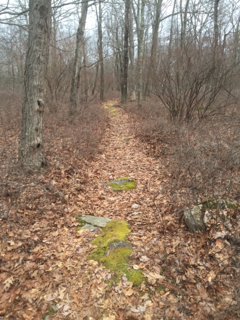
We made a right on Hay Road, and followed it for about 1.5 miles through logging country. As the road went from hard packed gravel to 4-5 inch rip rap, we turned around and headed back to the intersection, where we took Pine Flats Road. We came to a creek that, aided by the recent rains, overtook the road. After a few more miles, we made a left on Rt. 402, and climbed our way back to the parking area. We talked of ways to connect this route to a few other gravel roads, making for a 50-70 mile ride on mostly gravel.

Screenshot (7)


Sunrise Trails

Well, winter is finally here. With a couple of moderate snowfalls and a weekend of sub zero temperatures, I think it’s safe to say that it’s winter, even if it did not rear its ugly head until mid-February! Since, my Van Dessel WTF is back in service, I was itching to get out and see what it felt like with 29×2.1 tires. I decided to leave right from my house in Conashaugh Lakes, and ride up to a short deer trail that connects the community with Five Mile Meadow Road.

IMG_2209

It was about 25 degrees and cloudy at noon, and there was a bit of wind. I turned right onto Five Mile, and followed it up and down until I crossed Rt. 739. There is a parking area at 739 with a trail that snakes around it to avoid a locked gate when it’s not hunting season. A gravel jeep road drops down for about 1 1/2 miles, and ends at the edge of Rt. 84. A right takes you into a nice network of trails that is easily rideable on a mtb, cyclocross, or gravel bike.

IMG_2210

The first descent was pretty cool, down a grassy hill with what seemed like roadway rumple strips. After a quick hike a bike across a half -frozen creek, I was back on the trail, and climbing a somewhat steep hill that put me at a spot overlooking 2 creeks coming together. I had to stop for lunch here as it seemed about the flattest spot on the trail.

IMG_2211
Seemed like a good lunch stop

After lunch, I descended down a short rocky section, and was met with some pretty nice single track that swooped and swirled all around what I believe is PA State Gameland, tucked in behind the Sunrise Lakes and Lake Adventure communities. The only downside was the ice that seemed to freeze over low lying sections of the trail. After hitting about 5.5 miles of the trail, I was back on the jeep road and headed back as the cold was penatrating my shoes.

I will explore these trails more as the spring warms things up a bit. An intermediate ride on a trail that begs to be ridden. It’s a secret paradise for mountain bikers and adventure seekers!

IMG_2212


Old Mine, Buttermilk Falls, Walpack & Peter’s Valley

Super Bowl Sunday! So why can’t I just sit on the couch, watch the pre game chatter, and eat everything in sight? A look at the upcoming week’s weather, and I had to get one more ride in before Mother Nature shows us what winter really feels like. The plan was a McDade Trail ride, but Kyle suggested an alternate route that turned out to be a pleasant surprise.

IMG_3634

I met up with Eric and Kyle at Dingman Falls at around 10:30am. At 35 deegrees and sunny, it was perfect weather for a gravel ride. We headed out over the Dingman Bridge and into New Jersey. As described in an earlier post, the Dingman Bridge is a wooden surface bridge. A person stands in the middle, and collects a $1 toll from each passing vehicle. From the bridge, we made the first right onto Old Mine Road and up the Peter’s Valley climb. At the top, a right hand turn puts you on old Old Mine Road, a hard packed gravel road that has seen better days. For 6 miles, you slither down, scoping out dilapidated barns and farmlife from another era.

IMG_2167

Old Mine dumps you onto the Walpack Loop. Making a right, we climbed a bit, came to the fork in the road, and hung a hard right. Going up and over the top, we descended down to the beginning and off to the next off road section. A left hand turn put us on Mountain Road. A mix of dirt, gravel and sand, Mountain Road still had plenty of ice from last weeks snow storm. After about 2 miles, we were treated to an awesome sight, “Buttermilk Falls”.

IMG_2154
Buttermilk Falls

Buttermilk Falls (in the Delaware Water Gap) is a picturesque waterfall right by the road. It cascades spectacularly, 90 feet down the red shale face off the Kittatinny Ridge. It is the only waterfall in New Jersey, apart from Great Falls, with a developed viewing area: the National Park Service has erected an interpretive display and built a wooden walkway to the topnot a bad place to be on a February afternoon. Mountain Road took us through a series of bridges with locked gates across the road.

IMG_2149

Mountain Road came out onto Walpack Road just behind the Peter’s Valley Cemetery. As we came back to Peter’s Valley, we turned left onto Kuhn Road and followed it up to old Old Mine and took a a right. Back on gravel for about 2 more miles, Old Mine came back out on the top of the Peter’s Valley climb. We flew down to Rt. 560, and took another left back over the Dingman Bridge. Cruising back to the Dingman Falls parking area, instead of being happy with this ride, I was contemplating how I could connect this over to Van Ness or the McDade Trail to extend what was already a fantastic ride! 21 miles and 1,500 feet of elevation make this doable for almost anyone looking for a scenic ride.

Screenshot (2)

GUYMARD TURNPIKE

With the warm weather holding out for a few more days, today presented us with a golden opportunity to ride one of my favorite routes, Guymard Turnpike. A road ride, Guymard is on the New York side and we would have to navigate some traffic to get across the bridge.

I met up with Eric and Mike at Action Bikes and Outdoor (the premeiere bicycle and outdoor store in the tri state area), right in the heart of town. We headed out north on Rt. 209 and dodged some midday traffic, enabling us to make our way over the Port Jervis Bridge.

IMG_2119

Going under the train  tressel, we hung a left on Pike Street and weaved our way through the City of Port Jervis and over to Rt. 209, a secondary highway that connects Port Jervis with eastern Orange County, NY. Passing the Horse farm by Neversink Drive, we continued on Rt. 209 another few miles and turned right on Guymard Turnpike.

IMG_2122
Eric’s very pink socks

Guymard is a quiet back country road. It runs from 209 over to Old Mountain Road. Starting out, Guymard is a false flat for about a mile as it passes the KOA Camp Ground and goes over the bridge turning right and bears left. As it bears left, the hill steepens and twist and turns for 2+ miles. As you cap the hill and head down the backside, you are treated to a spectacular view of the Shawangunk Mountain range.

IMG_2123
Beautiful man made lake, halfway up Guymard Turnpike

After a short descent, we turned right on Old Mountain Road. Old Mountain is another secondary road with not much traffic, but the cars do move pretty fast. Old Mountain Road is a true blacktop rollercoaster. Momentum carries you over hill after hill until you reach Rt. 6, where the steepest part of the ride begins. Turning right on Rt. 6, you are immediately hit with a half mile of uphill pedaling. With our already tired legs, we capped the hill and enjoyed a 3 and 1/2 mile descent, dropping us right at the border of Montague, NJ and Port Jervis, NY.

IMG_2127

Turning right into Port Jervis and Left onto River Road and back into Montague, we made our way toward the Milford Bridge. River Road is another rollercoaster, stretching 6 miles through farmland. It ends right at the intersection of Deckertown Turnpike, Rt. 206, Old Mine Road and the Milford Bridge. The bridge, as I’ve written previously, has a steel bike path 5 feet lower than the vehicle lanes, passing over the Delaware River. Once back in Milford, we relaxed and enjoyed some java at the Frisky Goat Cafe. With 35+ miles and 2,388 feet of elevation, this ride is challenging enough for the fittest riders and scenic enough for the most casual riders.

Screenshot (1)

Snow, Sun and Fun!

Another beautifully warm winter day. 50 degrees on January 31st. With Last weekend’s snowfall of about 8 inches and temperatures hovering just above freezing all week, it was time to explore the back roads and see how much riding we could get in.

IMG_2109

I met up with Eric at the parking area on Rt. 739, adjacent to Five Mile Meadow Road. We began with a short climb up Five Mile, which was covered in a mix of snow and ice. It was a difficult climb as we could not seem to get any traction. Between the thaw and the pack down caused by passing pickup trucks, the road was extremely slippery on the ascent and an adventure to say the least on the following descent. Deciding to try another path, we hung a right onto Standing Stone Trail, which is a crushed gravel road, primarily used as a snowmobile trail. Covered in snow, with what looked like the tracks from a snowmobile, Standing Stone Trail was a much more viable option.

IMG_2115

The untouched snow, about 4 inches deep on either side of the snowmobile tracks was a pleasure to plow through. Standing Stone twists and turns with little incline, all the way to Silver Lake Road. We turned right and rode the pavement to Rt. 402. Recent construction has turned Rt.402 from a pothole filled back road into a nicely paved thoroughfare with enough shoulder to ride safely along.

IMG_2094

We made yet another right onto Hemlock Farms Road. From Rt. 402, Hemlock Farms Road climbs for about 3 miles, before offering up a steep descent down towards the golf course. Eric lead the way as we weaved through the golf course, past a cool dock that went out over a lake that made for a nice photo opportunity. As we made our way towards the exit gate of this picturesque country community, we were treated to the sight of more than a few beautiful stone and wood homes, that sit quietly in the Pennsylvania forest.

IMG_2103

We rode out of Hemlock Farms onto Rt. 739 and after another mile, we were back at the parking area. Bottom line…… Do not let the winter keep you inside. whether it’s 20 degrees or 50 degrees, find a way to get outside!