As autumn slowly winds down and winter approaches, the weather is getting colder and the days shorter. This leaves way too much time for yard work and holiday decorating, and not enough for riding. As anyone who knows me knows that I generally become full of excuses when it comes to riding in the cold weather (although, I usually do ride sporadically throughout the winter), the long winter certainly gives me plenty of time to reminisce about all the epic rides of the spring, summer and fall.
Milford’s benchmark road ride is from the center of town up to High Point, New Jersey. The ride is simply refered to by the local cycling culture as High Point.  Nestled atop High Point State Park in the Kittatinny Mountains, it is the highest point of elevation (1804′) in the state of New Jersey. The beautiful 220 foot high monument was built in 1928 as a war memorial. The base of the monument offers views of the Pocono Mountains to the west and the Catskill Mountains to the north. New York, New Jersey, and Pennsyvainia are all seen in what appears to be a panaramic view.
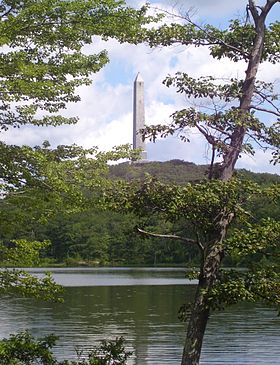
Starting from town, there are a number of different routes to take you up to the monument. First, the most common is Rt. 209 from Milford to the Port Jervis, New York bridge and under the overpass, and up Pike St. After turning right on Rt. 6 and taking it through Port Jervis and into Montague, New Jersey, you turn right on Rt. 23 and follow all the way up to the entrance to High Point State Park.
Another popular route is from town to the Milford bridge and take Deckertown Turnpike up and over to Sawmill Rd. Follow Sawmill to Rt. 23, and make a right and climb the last 1/2 mile to the park entrance. 
The toughest route, at least for a rider of my size, is up the Mashipacongs. From town to the Milford Bridge, make a left on River Rd. and follow to New Mashipacong Rd. Climb for a little over 3/4 of a mile, and descend to Clove Rd. Turn right and a quick left onto Old Mashipacong Rd. Climb for just about 2 miles. At the top, go through the gate and left into the park.
Once inside the park, follow for 1 1/2 miles, make a right, and go up the steep grade to the top of the parking area. Then, go left up another steep hill to the monument where you get rewarded with the aforementioned views.


This was greaat to read
LikeLiked by 1 person